
Open/Close Dates
- Unknown
Avalanche Conditions
Idaho Panhandle Avalanche Center
Avalanche.org
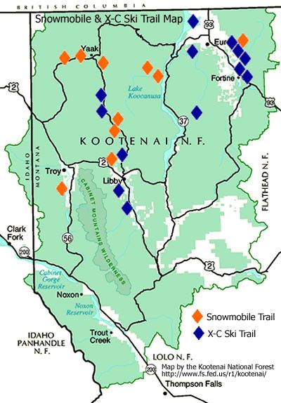
Trail Map
Get ready for a snowmobiling experience that will change the way you look at sledding. Kootenai Country Montana boasts over 200-miles of groomed trails and some extreme off-piste challenges that will take your breath away. The thick blankets of snow that cover our sparsely populated terrain will give you the ride of your life, and give you opportunities to take pictures and videos you will enjoy for a lifetime.
- Big Creek Baldy (16 Miles North of Libby, MT.)
- Purcell Trail (16 Miles North of Libby, MT.)
- Quartz Creek (6 Miles Northwest or 19 Miles Northwest of Libby, MT.)
- Safety Trail (14 Miles Northwest of Libby, MT.)
- Pete Creek Trail (3 Miles West of Yaak, MT.)
- Fourth of July Creek (17 Miles North of Troy, MT.)
- Meadow Creek Trail (10 Miles Southwest of Yaak, MT.)
- Spread Creek Trail (6 Miles Southwest of Yaak, MT.)
- Keeler Creek Trail (8 Miles South of Troy, MT.)
- North Creek/Beetle Creek Trail (6.5 Miles West of Yaak, MT. for Whitetail Creek access, & 7.5 Miles NW of Yaak-Beetle)


The Kootenai National Forest offers some of the finest snowmobiling areas in the state. Elevations on the Kootenai National Forest range from 1,862 to 8,712 feet. There are five Ranger Stations and the Forest Supervisor’s Office in the area which offer information pertaining to local snowmobiling opportunities.
Web Cams
NONE
Snotel
- Banfield Mountain 5600 ft
- Bear Mountain 5400 ft
- MAP
Weather
![]()
Forecast for Kootenai Forest Area area, MT
Search & Rescue
Call 911 or use your satellite communications device
Snowmobile Clubs
Parking
User Permits
Get Permits NowProducts & Services

Your one stop shop for aftermarket
snowmobile parts and accessories
Mountain Side Performance
Kremmling, CO
(970) 406-2722


Marlenee LLC Excavation & Marlenee Photography
6790 Hillside Drive
Idaho Falls, ID 83401
(970) 227-7977