Open/Close Dates
- 12″-24″
Avalanche Conditions
Sierra Avalanche Center
Avalanche.org
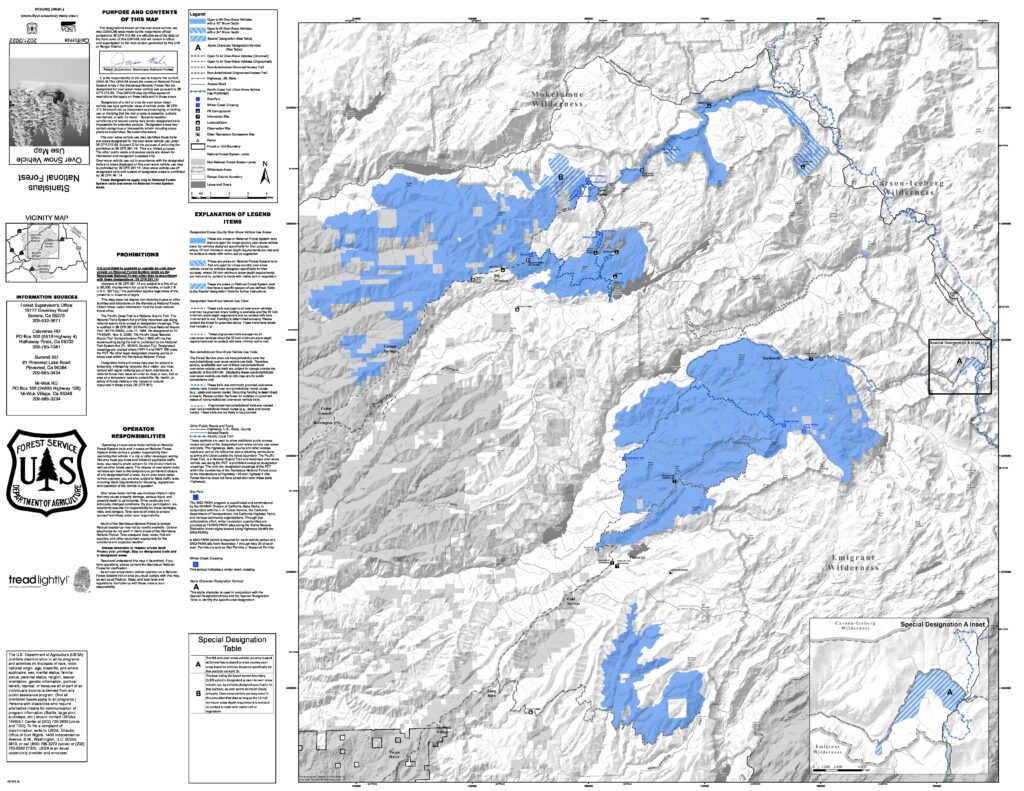
Trail Map

General Notes:
Includes the Bear Valley Access trail: 1.5 miles of intermediate trail that runs from the Lake Alpine SNO-PARK to Bear Valley Village. This trail provides users the opportunity to ride from Bear Valley to the Lake Alpine SNO-PARK to access the groomed trail.
During the winter months, Highway 4 is groomed for snowmobile use from the closure gate 2.5 miles east of Bear Valley to the top of Ebbetts Pass (approximately 15 miles) and to Highland Lakes. This trail has numerous segments, appropriate for different skill levels from novice to expert. As the trail climbs towards the pass, the views are spectacular. Opportunities exist for expert riders to continue riding on the un-groomed portion of the Highway on the east side of Ebbetts Pass. (Note: The groomed portion of Highway 4 is a multi-user trail, and is heavily used by nordic skiers as well as snowmobilers, particularly in the Lake Alpine region.)
You can pick up the most recent Over Snow Vehicle Use map at the Calaveras Ranger District office. Or download a Geotagged PDF of the Over Snow Vehicle Use Map here.
Check the current snow depth here: Snow Depth Map
Webcams
Nearest Snotel
- Ebbetts Pass 8661 ft
- Blue Lakes 8067 ft
- MAP
Weather
![]()
Search & Rescue
Calaveras County County Search & Rescue
Call 911 or (209) 754-6500
Call 911 or use your satellite communications device
Snowmobile Clubs
Not a club, but a Facebook Group
Bear Valley Area Snowmobile Riders
Parking
Directions:
| Parking: | Small parking lot and roadside parking along Hwy 4 west of the winter closure gate. |
|---|---|
| Toilets: | Vault |
User Permits
Get Permits NowProducts & Services

Your one stop shop for aftermarket
snowmobile parts and accessories
Mountain Side Performance
Kremmling, CO
(970) 406-2722


Marlenee LLC Excavation & Marlenee Photography
6790 Hillside Drive
Idaho Falls, ID 83401
(970) 227-7977
Lodging
List Your Business with UsRoad Conditions
NOT a LIVE image-click image or link for most recent image